Loleta Recreation Area
Sigel, Pennsylvania · on Sugarcamp Run · Allegheny National Forest
Verified · 4 independent sources · top-verified
- WATER
- creek
- ACCESS
- Designated swim area
- FEE
- $5/vehicle
- SEASON
- Spring
About Loleta Recreation Area
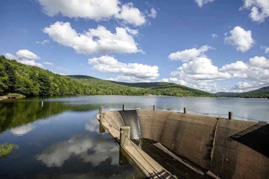
Loleta Recreation Area is a U.S. Forest Service campground and day-use site in the Allegheny National Forest, about 6-7 miles south of Marienville, PA, built on the site of a former 1880s logging town. It features an official swimming hole, a beach at a Civilian Conservation Corps-era dam impoundment on the east branch of Millstone Creek, along with a bathhouse, picnic areas, and campsites, making it one of the national forest's official places to swim.
The recreation area sits in a forested valley of the Allegheny National Forest along the east branch of Millstone Creek, on the former site of Loleta, a logging town established in 1889 that once had over 600 residents before the timber ran out around 1913. The Forest Service acquired the land in 1925, and Civilian Conservation Corps crews rebuilt it into a recreation site in the 1930s, leaving stonework and a dam still in use today. A three-mile marked hiking trail loops through the surrounding valley, and the Clarion River lies about four miles south.
Swimming at Loleta Recreation Area
Swimming takes place in a pond created by the CCC-era dam across Millstone Creek's east branch, adjacent to a bathhouse with changing rooms, flush toilets, and hot showers. Visitor accounts describe the swimming area as shallow and family-friendly, suited to cooling off and casual wading rather than deep-water swimming; the creek is also stocked with trout by the PA Fish and Boat Commission.
How to get to this swimming hole
From Marienville, PA, take PA Route 66 and then South Forest Street/Loleta Road south approximately 6-7.3 miles to the Loleta Recreation Area entrance sign.
Parking: Day-use vehicle parking is available at the recreation area for a fee (see fees); specific lot capacity or overflow conditions were not documented in sources found.
The hike in
Loleta Trail
Difficulty: Not rated in any source found; described only as a marked 3-mile loop through forest with one valley overlook.
Trailhead: Starts and ends at Loleta, from the parking lot near the group camping site (per USFS page); marked with off-white diamond blazes per a secondary source.
The swimming beach itself sits right at the day-use area next to parking -- no hike is required to reach the water. Separately, an optional ~3-mile loop trail circles through the woods around the upper camping loop and out to a scenic overlook of the Millstone Valley, but this loop is a bonus activity, not the access route to the swim beach.
Nearby Buzzard Swamp trail network (~9-10 miles of trails, ~15 ponds) is about 5 miles north for visitors wanting a longer hike.
Plan your visit
Bringing kids
Good for kids
Swimming pond is described by the USFS as a designated shallow swimming/wading beach; a visitor review (campingwithkayla.com) explicitly calls it a 'safe, shallow swimming beach' suited to young kids while parents relax, and separately calls the on-site loop trail 'kid-friendly.' No lifeguard is documented at the beach.
Parking
Paid, $5/vehicle day-use fee (or $65 season pass); separate from camping fees ($16/night standard site, $25/night electric)
Accessible day-use parking lots at the picnic/swim area; individual campsites also have their own parking spurs. No specific lot capacity or overflow guidance found.
Restrooms
Yes
Bathhouse at the day-use/swim area with flush toilets, hot showers, and changing rooms (one visitor review notes only one shower stall on the men's side, and that the bathhouse can be roughly a quarter mile from some campsites); vault toilets in both camping loops.
Hours
Campground open ~April 1-October 10; day-use area ~May 1-October 10; USFS's own page states the swimming/picnic area operates May 26-September 4 (Memorial Day-Labor Day). Note: Recreation.gov's campground listing contains conflicting boilerplate text stating the swimming area is 'off-limits between Memorial Day and Labor Day' -- this appears to contradict the USFS page and other visitor reports of summer swimming, so treat it as an unresolved discrepancy rather than fact. Quiet hours 10pm-6am; campground check-in 2pm/check-out 12pm. A 2026 notice on Recreation.gov states the whole area closes after Labor Day (9/8/26) for water system upgrades.
On the water
No source documents kayaks, canoes, paddleboards, or any boats being used on the small CCC-dam swim pond itself -- it is framed purely as a swim/wade beach. The USFS page does note that the Clarion National Wild and Scenic River, about 4 miles south of Loleta, offers canoe, kayak, and tube access, and that Millstone Creek has 'good' trout fishing, but this is a different, separate water body from the swim pond.
What regulars say
Visitor reports describe Loleta as generally quiet and peaceful, especially midweek, with no cell signal on site. One visitor warned that road signs and names on-site didn't match the campground map, causing confusion finding sites/facilities. Rattlesnakes are called out as fairly common in the surrounding forest, so visitors recommend keeping dogs leashed and watching your step off-trail.
Backstory
The site was the town of Loleta, a logging community established in 1889 with over 600 residents; it declined after timber resources were depleted around 1913. The federal government purchased the land in 1925, and Civilian Conservation Corps crews reconstructed it into a recreation area in the 1930s, including the dam that now impounds the swimming area; camping loops were added in the 1960s.
Loleta Recreation Area: FAQ
Does Loleta Recreation Area charge a fee?
Day use: $5/vehicle or $65/season pass. Camping: standard site $16/night, electric hookup site $25/night (per U.S. Forest Service).
Is Loleta Recreation Area kid friendly?
Swimming pond is described by the USFS as a designated shallow swimming/wading beach; a visitor review (campingwithkayla.com) explicitly calls it a 'safe, shallow swimming beach' suited to young kids while parents relax, and separately calls the on-site loop trail 'kid-friendly.' No lifeguard is documented at the beach.
Do I need to hike to reach Loleta Recreation Area?
No significant hike is required. The swimming area is close to parking and access.
Where do I park for Loleta Recreation Area?
Accessible day-use parking lots at the picnic/swim area; individual campsites also have their own parking spurs. No specific lot capacity or overflow guidance found.
When is the best time to visit Loleta Recreation Area?
Late spring through early fall (campground and swim beach generally operate mid-April to mid-October, with the swim beach itself open Memorial Day to Labor Day).
What are the rules at Loleta Recreation Area?
Swimming beach is open seasonally, roughly Memorial Day through Labor Day (one source cites 5/26-9/04); pets must be leashed and are not permitted on the beach or in the water; quiet hours 10pm-6am; fires only in provided rings/grills; no firearms, weapons, or fireworks; do not transport firewood from outside the forest. Note: Recreation.gov listed a 2026 closure of the whole recreation area after Labor Day (9/8/26) for water system upgrades.
What water body is Loleta Recreation Area on?
Loleta Recreation Area is on Sugarcamp Run, a natural creek verified in USGS hydrography data.
More swimming holes near Sigel
 ★ Top verified
Twin Lakes Recreation Area
Wilcox, Pennsylvanialake
⛺
New Providence Beach
DuBois, Pennsylvanialake
🛶🚤
Bimini beach
DuBois, Pennsylvanialake
🛶🚤
Kiasutha Recreational Area
Kane, Pennsylvaniareservoir
⛺🛶🏄🚤
Parker Dam State Park
Penfield, Pennsylvanialake
⛺🛶🏄🚤
Quaker Lake Beach House
Salamanca, New Yorklake
⛺🛶🏄