Hoyt’s Crossing
Nevada City, California · on South Yuba River · Mother Lode Field Office
Verified · 4 independent sources
- WATER
- river
- ACCESS
- Designated swim area
- FEE
- $10
- SEASON
- Best in summer
About Hoyt’s Crossing
Hoyt's Crossing is a South Yuba River swimming area reached via Hoyt's Trail inside South Yuba River State Park (Highway 49 Crossing area) near Nevada City, California. The trail runs about 1.2 miles upstream from the old Highway 49 bridge to a former river crossing and beach, with numerous granite-lined swimming holes along the way.
The trail follows the South Yuba River canyon through live oak woodland and chaparral with a southern exposure that keeps it warm on cool days; a semi-shaded path crosses seasonal streams lined with riparian plants such as western spicebush. The river here runs through a granite canyon with water-sculpted rock and small beaches, and a Miner's Tunnel outlet from historic mining is visible across the river about 0.35 miles from the trailhead.
Swimming at Hoyt’s Crossing
Multiple pools along and off the main trail range from shallow, calm wading areas near the bridge to deeper, current-fed pools with smooth granite floors and reported cliff-jumping (roughly 5 meters at the highest, with lower options). Water is clear, cold Sierra Nevada snowmelt; officials and trip reports agree currents can be deceptively strong, especially during spring runoff, so many visitors treat mid-to-late summer as the safer swimming window.
How to get to this swimming hole
From Nevada City, follow Highway 49 north/west to the Highway 49 Crossing of the South Yuba River (South Yuba River State Park); Hoyt's Trail begins at the north end of the old Highway 49 bridge and runs upstream along the river to Hoyt's Crossing.
Parking: Day-use parking at the Highway 49 Crossing area near the old bridge; first-hand reports note the lot fills quickly on warm weekends and recommend arriving by 8-9 AM.
The hike in
Hoyt's Trail (also called Hoyt Trail)
- To the water
- About 1.2-1.5 miles one-way to Hoyt's Crossing beach (official park sources say ~1.2 mi; one recent visitor reports ~1.5 mi, roughly a 20-45 minute walk at an easy pace)
- Time on foot
- Roughly 20-45 minutes one-way to the main beach at an easy pace; another 20-45 minutes beyond that to reach the cliff-jump area
Difficulty: Easy to moderate on the main trail to the beach (described as a scenic river walk); the Hoyt Crossing Road extension and the spur to the jump site are more vigorous, with hand-and-foot scrambling in places
Trailhead: North end of the old Highway 49 bridge at the South Yuba River State Park's Highway 49 Crossing day-use area, about 6.9 miles northwest of Nevada City off Hwy 49
The main out-and-back trail from the bridge to Hoyt's Crossing beach is ~1.2-1.5 mi one-way (2.4-3 mi round trip); an optional extension via old Hoyt Crossing Road makes a more vigorous ~4.5-mile round trip. A further unofficial spur continues roughly another 20-45 minutes past the main beach to a cliff-jumping area, on a narrower trail with a steep sandy rise, rock scrambling, and a cable-assisted section.
A visible Miner's Tunnel outlet from historic mining sits across the river about 0.35 miles from the trailhead. Narrow stretches with steep drop-offs require confident footing; water shoes are recommended for slippery granite.
Plan your visit
Bringing kids
OK with supervision
Shallow wading spots exist near the old Hwy 49 bridge, but the state park itself warns this stretch is 'more treacherous than other areas of the park' with currents that turn dangerous quickly, especially during spring snowmelt. A first-hand account also notes narrow trail sections with steep drop-offs, cold-shock risk, and slippery granite, and recommends close supervision and waiting until mid-July+ once currents ease.
Parking
Paid, $10 vehicle day-use fee (South Yuba River State Park entrance fee; covers parking)
Small day-use lot at the Highway 49 Crossing near the old bridge trailhead; a first-hand report says it fills quickly on warm weekends and recommends arriving by 8-9 AM.
Restrooms
Yes
Portable (vault-style) restrooms near the trailhead at the old Highway 49 bridge, per a first-hand visitor account; the park's general visitor-info page also lists restrooms and drinking water as available park-wide (not confirmed as a Hoyt's-Crossing-specific facility).
Water clarity
Clear
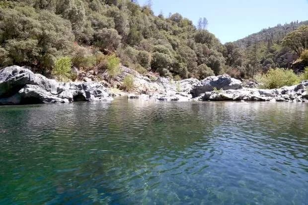
First-hand accounts describe the water as a deep jewel-toned teal/turquoise, cold Sierra Nevada snowmelt, with smooth granite pool floors visible from the surface.
Hours
Sunrise to sunset, day-use only (South Yuba River State Park)
On the water
No source found describing kayak, canoe, paddleboard, or tube use specifically at Hoyt's Crossing. Official park material instead emphasizes that this stretch runs swift and is 'more treacherous than other areas of the park,' consistent with it being a swim/cliff-jump spot rather than a paddling destination; loaner life jackets provided at the crossing are for swimmers, not boaters.
What regulars say
Insights here come from first-hand visitor trip reports: water is a clear teal/turquoise with visible granite floors; the small trailhead lot fills by mid-morning on warm weekends (arrive 8-9 AM); the walk in is easy but has narrow, steep-drop sections needing care; cell service is minimal in the canyon; a further unofficial spur beyond the main beach leads to a cliff-jumping area (roughly 1-5 meters) used mainly from mid-June to early November, with a clothing-optional norm reported at part of the beach; visitors are advised to wait until mid-July or later once spring runoff currents ease.
Backstory
Hoyt Crossing Road was an early Gold Rush-era route connecting Nevada City to the Columbia and North San Juan gold fields, and the crossing itself once had a toll bridge operated by Moses Hoyt, Nevada City's first mayor. Historic mining features, including a Miner's Tunnel outlet, are visible from the trail.
Hoyt’s Crossing: FAQ
Does Hoyt’s Crossing charge a fee?
$10 vehicle day-use fee for South Yuba River State Park (California State Park annual passes such as the Golden Poppy Pass and California Explorer Pass are accepted).
Is Hoyt’s Crossing kid friendly?
Shallow wading spots exist near the old Hwy 49 bridge, but the state park itself warns this stretch is 'more treacherous than other areas of the park' with currents that turn dangerous quickly, especially during spring snowmelt. A first-hand account also notes narrow trail sections with steep drop-offs, cold-shock risk, and slippery granite, and recommends close supervision and waiting until mid-July+ once currents ease.
How hard is the hike to Hoyt’s Crossing?
A hike is required, about About 1.2-1.5 miles one-way to Hoyt's Crossing beach (official park sources say ~1.2 mi; one recent visitor reports ~1.5 mi, roughly a 20-45 minute walk at an easy pace) to the water (roughly 20-45 minutes one-way to the main beach at an easy pace; another 20-45 minutes beyond that to reach the cliff-jump area). Wear real shoes, since approaches to natural swim spots are often rocky or rooty.
Where do I park for Hoyt’s Crossing?
Small day-use lot at the Highway 49 Crossing near the old bridge trailhead; a first-hand report says it fills quickly on warm weekends and recommends arriving by 8-9 AM.
When is the best time to visit Hoyt’s Crossing?
Late summer is cited by the state park as the best time for the swimming holes; first-hand accounts suggest mid-July onward as safer once spring snowmelt currents subside, with a reported cliff-jumping season of roughly mid-June through early November.
What are the rules at Hoyt’s Crossing?
Park is day-use only, open sunrise to sunset; no fires, alcohol, glass, or barbecues; dogs are allowed on trails and the shoreline (except the separate Family Beach area of the park); loaner life jackets are available at the Highway 49 crossing.
What water body is Hoyt’s Crossing on?
Hoyt’s Crossing is on South Yuba River, a natural river verified in USGS hydrography data.
More swimming holes near Nevada City
Jones Bar
Nevada City, Californiariver
🥾 1.5 mi hike⛺
 ★ Top verified
South Yuba Recreation Area
Nevada City, Californiariver
⛺🛶
 ★ Top verified
North Fork Falls
Emigrant Gap, Californiawaterfall pool
🥾 0.25 mi hike⛺
Upper Lake Clementine Beach
Auburn, Californiareservoir
⛺🛶🏄
Auburn Swim Hole on American River
Auburn, Californiariver
🥾 0.1 mi hike⛺🛶🛟
 ★ Top verified
Wild Plum Campground
Sierra City, Californiacreek
🥾 0.5 mi hike⛺